Contour View of House Area
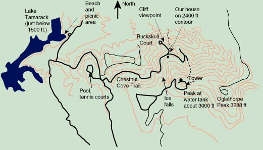
This locates our house on the North side of Big Stump Mountain, which forms a western shoulder on Mt. Oglethorpe. The dashed line from the end of the road to the tower location is roughly our hiking route when we take the RAs or other groups on a hike. Hiking to the top of Thunderstruck Drive and then proceeding up the ridge, we get to the tower and the water tanks on the top of Big Stump Mountain. Then we take a service road down from the water tanks and finally come down the very steep slope behind our house. Our standard description of the hike is that it is "45 minutes up and 15 minutes down... unless you slip, and then it's 5 minutes down." The other dashed line which leads northward from Buckskull Court is along a logging road which follows a small creek down to the area of the Bent Tree Reservoir. The contour lines are 100 foot contours from a topological quad map of the area.
|
Index
Bent Tree |