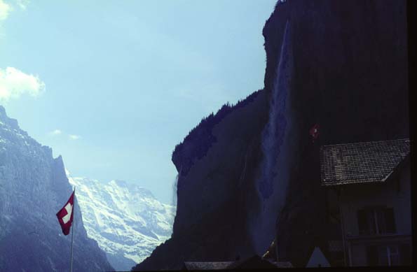
The Staubbach Falls Signal Good Weather

The falls are drifting to the left, which signals good weather ahead. If they drift to the right, expect rain ahead. At least that is what our neighbor in the campground told us. She was a very friendly lady from the Netherlands. These falls drop so far (almost 1000 ft) that most of the water turns to mist before it hits - it looks something like a lace curtain. It is interesting to watch the changes in the fall - an extra volume of water causes a streamer to depart from the main course, like a thin white finger probing downward until it vaporizes into mist. The fall actually drifts a considerable distance in the wind as it comes down; when it blows left it travels down one watercourse and to the right another! When we came into camp with the falls blowing left, there was a torrent of water down a little waterway through the camp. Now at twilight the falls are coming straight down and the waterway is bone dry. June 5, 1967

Index

Daily log
  Nave Album****Europe trip chronology Go Back


Lauterbrunnen From Base of Staubbach Falls

After our long day's hike, we returned to the base of the Staubbach Falls and got this view of the village of Lauterbrunnen. By this time we were becoming very fond of it.

Behind Lauterbrunnen, up on the ledge of the eastern cliff is part of the town of Wengen. June 5, 1967

Index

Daily log
  Nave Album****Europe trip chronology Go Back


Jungfrau Campground at Lauterbrunnen

The second orange tent to the right of the base of the flagpole is our tent in the Lauterbrunnen campground. Above us on the ridge behind the campground is the resort town of Wengen which must be accessed from the high road over the east cliff. June 5, 1967

Index

Daily log
  Nave Album****Europe trip chronology Go Back


Working Barn at the Campground

Haying is a big thing in Switzerland. They have to feed the cows all winter while this is covered with snow, so you see a lot of people out in the fields gathering hay. It surprised me that they gather it green, but perhaps these multilayered barns let it dry without mildewing like it would in Georgia. June 5, 1967

Index

Daily log
  Nave Album****Europe trip chronology Go Back


Twilight View of Lauterbrunnen Valley

The western cliff is now in deep shadow, with just the profiles of the waterfalls showing. But the Grosshorn and Breithorn at the end of the valley are still in sun and brilliant in their snow cover. The nearest waterfall is the Staubbach Falls. June 5, 1967

Index

Daily log
  Nave Album****Europe trip chronology Go Back


Sunset View of Lauterbrunnen Valley

The entire valley is now in deep shadow. But the Grosshorn and Breithorn at the end of the valley are still catching the red rays of the setting sun. We sat at the tent and watched the reddening peaks. It was an awesome end to a memorable day. June 5, 1967

Lauterbrunnen to Grindelwald
Index

Daily log
  Nave Album****Europe trip chronology Go Back