Daily Log
|
|
Index Daily Log |
| Nave Album****1982 West Trip | Go Back |
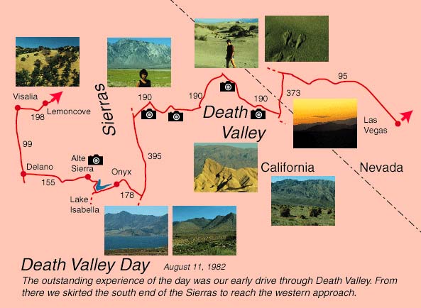
August 11: Death Valley to Southern CaliforniaStarting trip mileage 2845 miles. We got up at 3:30 AM! and hit the road at 4 AM in order to hit Death Valley early, before it got unbearably hot. It was 89°F as we left Las Vegas, having been about 100°F when we went to bed around 10PM. Brenda and the boys lay down in the van to get a little more sleep. I drove in darkness out Hwy 95 to Indian Springs (military town) and then the tiny Springs - and then nothing! I drove for about 35 miles in the dawn without seeing a house, a sign - the desert plants were the only thing there. This was the longest stretch of nothing I have ever seen. I was apprehensive about the van and about missing the small Hwy 373 to Death Valley Junction. I needn't have worried - Highway 373 stood out like a sore thumb in the nothingness, and then I started to see mining evidences, the Farm and other signs of life. The sunrise was very beautiful out on Hwy 373. Reaching the few buildings of Death Valley Junction about 6 AM, we found it deserted. We headed on into Death Valley with more confidence in the daylight. While it had been 89°F in Las Vegas at 4AM, it was comfortable to cool in the moving van. We stopped at Zabriskie Point to look and take pictures, parking the van on an incline. Sure enough, the van wouldn't restart in Death Valley - but it rolled off to a start easily. The boys had gotten good at pushing off the van, and could now brag "We even pushed it off in Death Valley!" We bought gas at Furnace Creek, and Brenda mailed some cards at the Death Valley Post Office. It was at an altitude of 178ft below sea level. We were amused by altitude signs reading "Sea Level" or "5 ft". We viewed the salt flat and the Funeral Mountains. At one point Jeff and I walked out to some sand dunes. We expected some snake evidence - but there were snake tracks everywhere on the dunes. In one case a snake track came from one direction, mouse tracks from another and then there was a wallowed out place of struggle. Jeff drove a little way in Death Valley - so he could say he did it. As we started out of Death Valley we had a steady climb from sea level through 1000 ft, 2000 ft, ... up to the Towne Pass at 4956 ft. An amazingly continuous incline. It was about 6% grade for 3 miles but then we went down at 9% for 6 miles, down to sand flats at less than 2000 ft. Then we climbed another hump to about 5000 ft. As we toped this second hump we caught sight of the high Sierras. As we crossed the desert plain on 190 the Sierras loomed larger and larger, desert in appearance but with patches of snow at the top. It was clear why there is no road over them. We joined Hwy 395 and headed south - I was surprised to still be in desert. The majestic Sierras were almost bare on the east side except for some trees at higher altitudes. We stopped at a rest area looking up at the mountains and I finally had breakfast. Brenda drove southward and we turned west on Hwy 178 and started heading up into the south end of the Sierras. Again I was surprised that we were still in desert country. I had expected that we would quickly climb into forested area. The Sierras are a very efficient moisture trap and the mountain slopes to the east are very dry. We climbed though some dramatic Joshua Tree forests and then went down a river valley. We saw cattle and horses and the characteristic hay growing under irrigation that we have seen in other desert river areas. We stopped at a bar near Lake Isabella to get gas because it had the only gas pumps we had seen in 50 miles. The scarred, tough-looking barkeep would not let us pump gas until we paid. He directed us to a slightly tipsy patron for directions to Kernville. The man told us the bypass to Kernville was more scenic than the 178 and 155, so we took his advice and it did turn out to give a lovely view of the lake and was a good road. After buying some grocieries in Kernville, we headed up the road to Johnsondale, only to run into a sign which told us the road was closed except every two hours. A lady at an inn called the forest service for us and found that the bridge across the Kern River was being worked on - and she wasn't sure the road would open at 4PM, the time we would be there. We decided to head for the valley on Route 155 and go around. When we retraced to Wofford Heights and started up the road toward Alte Sierra, we encountered a sign whch warned "Winding Roads and Steep Grades Next 30 Miles". The sign was not kidding!! The old VW Van was soon in first gear and straining. For probably 6-8 miles we climbed a steep winding grade which probably reached 20% grade in places. There were some switchbacks the VW barely made in first gear. Despite the anxiety about the vehicle, we had to admire the scenery - our first taste of the high Sierra. The winding rad was dotted with little vacation houses set deep in the evergreen forest. We saw our first sequoia trees, though small, young ones - probably only a few hundred years old. When we finally reached the summit at Alta Sierra there were obviously long-established camps, some church related and some private. A big deer crossed the road in the deep forest. Going down also held some anxiety because the grades were just as steep. I stayed in 2nd gear, tapping the brakes to keep from over-revving the engine. Looking back at turnouts we got a beautiful view of the evergreen Sierra forest on the mountain. Soon it was evergreens dotting grassy hills. Then it was hardwoods dotting golden grassy hills. Then it was just golden, grassy hills with firebreaks polowed around them to counter the obvioulsly great fire hazards. The resort community had given way to farms and a rural feeling, but still the road rocked and twisted and humped over the natural terrain with no grade development and not a 50 yard straight stretch anywhere. It was very beautiful, what we have heard called one of California's "old roads" - but it took us over 2 hours to travel 30 miles. Time wise, it would have made better sense to take Hwys 395,14,58 and 65, even though much longer. But I was grateful for the exposure - the van should make it over anything we encounter - but it will be wise to stick to California's "new roads" from now on. Jumping off 155 onto 65 North, we found it to be a well engineered, straight, fast road through Porterville. The very hot weather there was suited to the growing of oranges, grapes, etc. and we passed through miles of groves. Taking 198 toward Sequoia National Park, we stoped abouty 5PM at a small KOA Campground at Lemoncove. For my money it was the best KOA experience even though limited in facilities - or maybe because it lacked facilities. The bad experience of the big KOA city in Flagstaff lingered in my mind. This KOA was grasssy, rural, with a good view of the grass covered hills building to the Sierras. We had a lovely sunset and a clear, starlit night. The boys swam for a couple of hours in the pool and we relaxed a bit. This was a good day. We made the leap across Death Valley, which the boys seemed to enjoy grreatly, and passed through many changes and varied, beautiful scenery. In the vastness of the west, we have not found any dull drives. Thank the Lord for a beautiful day! 442 miles on the day.
|
Index | |
| Nave Album****1982 West Trip | Go Back |