Daily Log
|
|
Index Daily Log |
| Nave Album****1982 West Trip | Go Back |
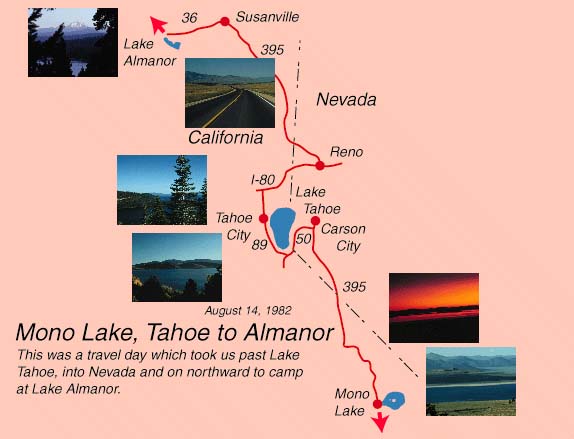
Mono Lake, Lake Tahoe, Lake AlmanorBeginning trip mileage 3605 miles. We pulled out of the Mono Lake campground about 5:30 AM and I stopped to take pictures of the sunrise over Mono Lake. We climbed to the Conway Summit at 8138 ft. Driving northward on 395 we passed Devil's Gap and then began to follow another really beautiful mountain stream, the West Walker River. The exquisite stream was dotted with campers and early morning fishermen. This stream cascades down through essentially desert country. I had planned to take the smaller Hwy 89 across to Lake Tahoe from 395 but local contacts persuaded us otherwise. I talked to the girl at the information office for Mono Lake and she said 395 to Minden would be faster - 89 is an "old road" and very slow. When I got back to the campground ( I had walked with the boys into the little town) Brenda had had a long conversation with a young California couple parked a couple of spaces down from us and they had just come down the road from Tahoe to Minden and they recommended not taking it but proceeding to Hwy 50 near Carson City. We took their advice and zipped along the fast 395 and took 50, climbing from about 4700 ft to the summit at 7140 ft. Hw 50 was a new 4-lane road whch we could move along as fast as the van would take the grade, so staying with the big roads is definitely the smart thing to do in those mountains. Along 50 we came out of desert hills to sierra type forests again as we climbed. There were still snow patches on the mountains and you got a good distant view of the mountains. This would be a good road on which to see the Sierras in the snow. We topped the summit and almost immediately saw the blue expanse of Lake Tahoe in the distance. We could watch the lake as we came in closer. Taking 50 south along the shore through South Tahoe was a big disappointment however. It Was so developed with casinos, etc. on the Nevada side and Bankhead Hwy type junk on the California side that it spoiled the beauty of the lake. We stopped for breakfast at McDonalds in South Tahoe, which was OK but crowded, and the boys didn't behave well. Rounding the south end of Tahoe on 89 our perception of the area improved. In the State Park recreation area we got back into the forest - it was crowded and packed with campers and boaters though. Emerald Cove with its nice bluegreen water, boats, and huge pine trees was a beautiful place. We could understand what we have read about the beauty of Tahoe on that side. We pulled up at a turnout to find that we had a flat on the right rear, so the boys and I changed it. I dropped Brenda and the boys off at a public picnic area along the lake and proceeded to Tahoe City to get the tire fixed. Tahoe City was jam-packed with young people renting rafts and afting down the river out of Tahoe. I had to drop the tire off for an hour so I returned to the picnic area where the boys had done some wading but little swimming in the cold water. The water waa beautifully clear and we had a good view of sailors, skiers, jetskis, etc. out on the lake. Returning to Tahoe City, the service station man hadn't looked at the tire. He pumped it up and found a cut on the tire side where we had run over something - so it couldn't be fixed. Going across the street to the Chevron station to get gas, I found that he had tires for a reasonable price so I had him put one on while I waited and Brenda got some groceries. Everyting worked out pretty efficiently so we didn't lose much time. Our California camper acquantances had recommended taking I80 to Reno and 395 to near Susanville rather than the slow 89 cross country through the mountains. This we did and found it to be very fast so we rolled on through desert and then expansive rolling desert mountain terrain. We passed Honey Lake which was so named because of its honey color - but to us it looked muddy - we never figured out why. Jeff did a good job of navigating as we left 395 to 44 and then to 36. Susanville and other small places along this routhe looked like old western towns - which as a matter of fact they were. Jeff located a campsite that he liked the sound of on Lake Almanor near , which we had never heard of . We located the turnoffs and wound our way through small resort motels and camping areas on the power company-controlled lake - similar to Alatoona except it was in the high evergreen forest. We drove hesitantly into the campground right on the lake and finally found the office in the little store off a deck where people were playing ping-pong and other games. There was one space left - because a reserved week camper had not shown up - so we pulled the van in the lot in view of the lake and boats. It was very different from the KOA's and other overnight facilities. All the kids knew each other - most of the people had been coming there for years for their vacations. I was a little uneasy in that setting but the facilities were nice. We didn't take advantage of the two movies they showed, and couldn't get any time on the busy ping-pong table - but we walked on the lake and enjoyed the scenery. Brenda called Wanda from the campground because we planned to hit Crater lake in two days. She found that they ahd been expecting to hear from us all day to meet us at Crater Lake-so we regreetted inconveniencing then - we had told them before the trip that we would probably get to Beaverton on the 15th.
|
Index | |
| Nave Album****1982 West Trip | Go Back |