
Daily Log
|
|
Index Daily Log |
| Nave Album****1982 West Trip | Go Back |
 |
Index Map for Day 16 |
| Nave Album****1982 West Trip | Go Back |
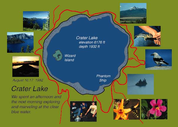
August 16: Redwoods, Crater LakeBeginning trip mileage 4234 miles. We really enjoyed our electric blanket in the cool sea air and had a good nights sleep. We left about 6AM in a cool fog to drive up the few miles to the Redwood Forest National Park. Approaching the park entrance we started seeing isolated trees sticking well up above the surrounding forest and we assumed these to be coast redwoods. The park entrance was almost unheralded because there is no entrance booth (no fee) and Hwy 101 runs right through the park since there is no alternate route. We started seeing large redwoods by the roadside in the dim light. They are not as big around as the sequoias of Sequoia National Park but rise to incredible heights. We didn't take the side routes in the first part of the park but proceeded on toward where there was a circle road which ran close to the sea. It turned out to be a narrow gravel road which ran along bluffs overlooking the rocky seafront. There was very little beach, but the view along the rocky coast was very pretty. We stopped at a turnout overlooking the ocean to the south and ate our breakfast. We had a good conversation with a couple from Washington state near Puget Sound. They had two boys 17 & 19 who did not come with them and they told us we were traveling at the right time - once the boys were a couple of years older they wouldn't want to travel with us. We made the circle feeling that as a National Park, the redwood area was very poorly maintained. We made the beach circle and headed on toward Crescent City. We turned off on 199 and went through the Jedediah Smith Redwoods State Park where we saw the nicest stands of redwoods on the quick drive through. We were pressed for time, but felt a bit cheated by the lack of organizaiton of the area. If we had had better information we could have seen much more in the brief time we had. The 199 was a very nice highway and we stayed in forest most of the rest of the day. We followed the Middle Fork of the Smith River for a time. Taking I5 at Grant's Pass we followed the Rogue River Valley and then took 62 toward Crater Lake. The impressive thing about route 62 was that it was solid forest. At points along it you were moving down a narow slot in an otherwise unbroken forest of towering pines. One part of it was appropriately named "Mammoth Pines Forest". It really was beautiful. We made good time along the straight roads and the main traffic we met was large trucks of logs. Nearer to Crater Lake we began to climb, going over a 6016 ft pass. We entered Crater Lake National Park and passed a campsite, Mazama Campsite, just as Brenda was reading in the park paper that it was the only one open this year. So we wheeled about and found a campsite and went through the self registration procedure. We put a tablecloth, our trash and dishes on the table, put a note on the site marker "Taken" and headed for Crater Lake. We viewed the lake first from the lodge area - it was unbelievable. I had heard about it, read about it, and seen pictures of it - but it still has to be seen to be believed. The deep blue was so brilliant in the strong afternoon sun coming over my shoulder. I wandered around taking pictures, Brenda went to the gift shop, and the boys fed the chipmunks. They had rather feed chipmunks than see any view - but we were glad they enjoyed it. After a couple of family pictures there we went around the rim to turnouts overlooking Wizard Island, the larger of the two islands. The chipmunks were even bolder there, and I got some pictures of them and a Clark's nutcracker, plus a couple of more shots of the lake. Brenda drove us around the rim drive while I handled my camera equipment. There were some fabulous views of the surrounding mountians and forests - thats one of the things a volcanic peak does for you - gets you up so that you get great long views of the surrounding country. The boys got to play in a patch of remaining packed snow. As we drove on around the east side of the lake the glare of the sun took away the blue color, but it was still dramitic. There were numerous patches of snow - one of the spur roads was still closed by snow and was not expected to open this year. Returning to the campground, we prepared to bed down - expecting temperatures in the low thirties. The boys built a fire and roasted weiners and marshmallows. Brenda also roasted a few marshmallows. Brenda and the boys went to the campfire and heard a program and saw slides about the park.
|
Index | |
| Nave Album****1982 West Trip | Go Back |