Paleomagnetism
Studies of the magnetic field orientations in rock strata reinforced the case for plate tectonics.
 | Iron-rich magnetic minerals such as magnetite are present in basaltic lava flows. A characteristic of ferromagnetism is that it disappears when you heat the material above a temperature known as the Curie temperature, which is 1043K for pure iron, but is reported to be about 850 K (580°C) for magnetite. When these minerals drop below their Curie temperatures in the process of solidifying, they are slightly magnetized in the direction of the Earth's magnetic field at this time. This forms a durable record of the direction of the magnetic field of the Earth at the time of solidification.
|
The magnetic North and South poles of the Earth correspond closely, although not exactly, with the spin axis of the Earth. Although the mechanism of generation of the magnetic field, called the geodynamo, is not fully understood, it is clear that it has something to do with the rotation of the Earth and the presence of mobile materials with significant electrical conductivity which can circulate. Mars has a similar rotation rate, but apparently no mobile conductors and therefore no appreciable magnetic field. Because of the enormous angular momentum of the Earth and the absence of a source of torque to change that angular momentum, we can presume that the spin axis has remained essentially constant in space. | 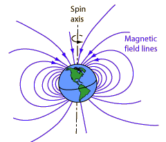
|
The magnetic field at any point on the Earth would orient a compass in the direction of magnetic North. The compass needle is a mobile magnet that rotates to align with the magntic field. Measurement of the magnetic field direction at a point on the Earth could tell you where the magnetic North pole is at that time, but you would have to measure the dip angle as well as the direction parallel to the surface to imply the pole location.
The illustration below follows the treatment of Lutgens and Tarbuck who trace the evidence for plate tectonics that comes from the study of the magnetization of minerals. Studies of lava flows in Europe during the 1950s and later in North America showed a change in the orientation of the magnetic field with the age of the lava. This was taken as evidence that the magnetic poles "wandered" over the surface of the Earth. But given the stability of the Earth's rotation axis and it's association with the magnetic field generation as discussed above, it seems more likely that the land mass itself had "wandered", i.e., undergone plate tectonic movement.
A problem arose with the comparison of the Eurasian and North American studies, since they showed different paths for the "pole wandering". But it was found that if you migrated the North American continent over toward the African continent, the curves came into congruence. The "problem" of different pole wandering paths became powerful evidence that the continents themselves had changed their relative positions in comparison to a presumably almost stationary magnetic pole.

|
Index
Reference
Lutgens and Tarbuck
Ch 16 |