The Pale Blue Dot

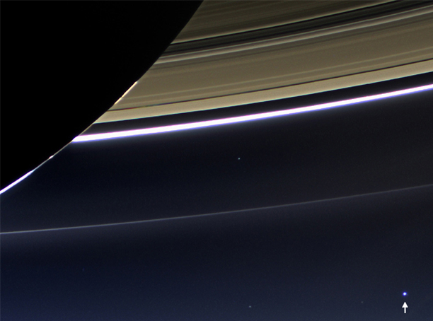
The late 20th century brought the capability to actually observe the planet Earth from space. One of the iconic photos was provided by Voyager I in its last series of photos before it left the solar system, the photo known as the Pale Blue Dot.

The photo was taken by Voyager's camera on February 14, 1990, just 34 minutes before it powered off its cameras (Photo credit NASA/JPL-Caltech). It was a part of a final 60 image photo collection termed the "Family Portrait of the Solar System". The popular name of this view is traced to the title of the 1994 book by Voyager imaging scientist Carl Sagan, who originated the idea of using Voyager's cameras to image the distant Earth.

The image of the Earth was taken from a distance of 3.8 billion miles (6 billion kilometers). This is the most distant view of the Earth. Turning the cameras back toward the Earth at an earlier stage posed risks to the camera systems because of the closeness of the Earth to the Sun and the brilliance of the Sun. The band of light in which the Earth image appears is sunlight scattered in the camera.

Overview of Voyager journeys
Index

Solar System Illustration

Solar System Concepts

NASA Pale Blue Dot Revisited
 
HyperPhysics********** Astrophysics R Nave
Go Back


Earth as Seen Through Saturn's Rings

"From 898 million miles away, Earth appears as a tiny blue dot in this wide angle photograph from the Cassini spacecraft." (Image credit: NASA/JPL-Caltech/Space Science Institute)

Index

Solar System Illustration

Solar System Concepts

Explorer1 galleries
 
HyperPhysics********** Astrophysics R Nave
Go Back


Earth and Moon as Seen from Mercury

In 2010 "on its way to orbit Mercury, the Messenger robotic spacecraft looked back and took this photograph showing Earth and the Moon as small circles of reflected light from a distance equal to the view from Mercury. Launched in 2004, Messenger's mission to the Sun's closest planetary neighbor ended with a dramatic, planned impact in 2015." (Image credit: NASA/Johns Hopkins University Applied Physics Laboratory/Carnegie Institution for Science)

Note that the mean distance between Earth and the Moon is about 30 times the diameter of the Earth. So the image above is taken at an orbital position that makes it look much closer than the actual separation distance.


For the one opportunity we have had to photograph Earth and the Moon from Mercury, it was very close to transiting the Earth!

Images of Moon and Earth to scale.
Index

Solar System Illustration

Solar System Concepts

Explorer1 galleries
 
HyperPhysics********** Astrophysics R Nave
Go Back


Earthrise

This classic image of the Earth from space was taken by Astronaut William Anders on the Apollo 8 mission. Apollo 8, launched on December 21, 1968, was the first manned vehicle to navigate around the Moon, and this photo changed our view of our home planet in a dramatic way.

Overview of the Apollo program.
Index

Solar System Illustration

Solar System Concepts
 
HyperPhysics********** Astrophysics R Nave
Go Back


Earthrise 2.0

The Earthrise 2.0 image was taken in 2015 by the Lunar Reconnaissance Orbiter (LRO). The LRO was launched in 2009 and captures about 10 Earthrises daily, "but is generally busy looking at the Moon's surface." (Image credit NASA/Goddard/Arizona State University).

Lunar Reconnaissance Orbiter (LRO)
Index

Solar System Illustration

Solar System Concepts
 
HyperPhysics********** Astrophysics R Nave
Go Back


The Blue Marble

This image of the Earth is a classic one over the continent of Africa. This is the famous "Blue Marble" image taken on December 7, 1972 by the Apollo 17 astronauts. It was taken from a distance of about 18,000 miles as they were traveling to the Moon. (credit NASA Johnson Space center).

Index

Solar System Illustration

Solar System Concepts
 
HyperPhysics********** Astrophysics R Nave
Go Back


The Earth/Moon System

"The rarely seen "dark side" is visible as the Moon moves in front of the sunlit side of Earth. This unique 2015 view was captured by a NASA's Earth Polychromatic Imaging Camera (EPIC) aboard the Deep Space Climate Observatory (DSCOVR) satellite. DSCOVR's primary mission is real-time solar wind monitoring for the National Oceanic and Atmospheric Administration (NOAA), while EPIC maintains a constant view of the fully illuminated Earth as it rotates, providing scientific observation of ozone, vegetation, clout height and aerosols in the atmosphere. DSCOVR is a partnership between NASA, NOAA, and the U.S. Air Force. (Image credit: NASA/NOAA)

Index

Solar System Illustration

Solar System Concepts

Explorer1 galleries
 
HyperPhysics********** Astrophysics R Nave
Go Back